Deep Learning,
Deep Discoveries
One alumna’s pioneering use of artificial
intelligence to find hidden landscape
features leads to new revelations and
promises breakthroughs in geography,
archaeology, and beyond.
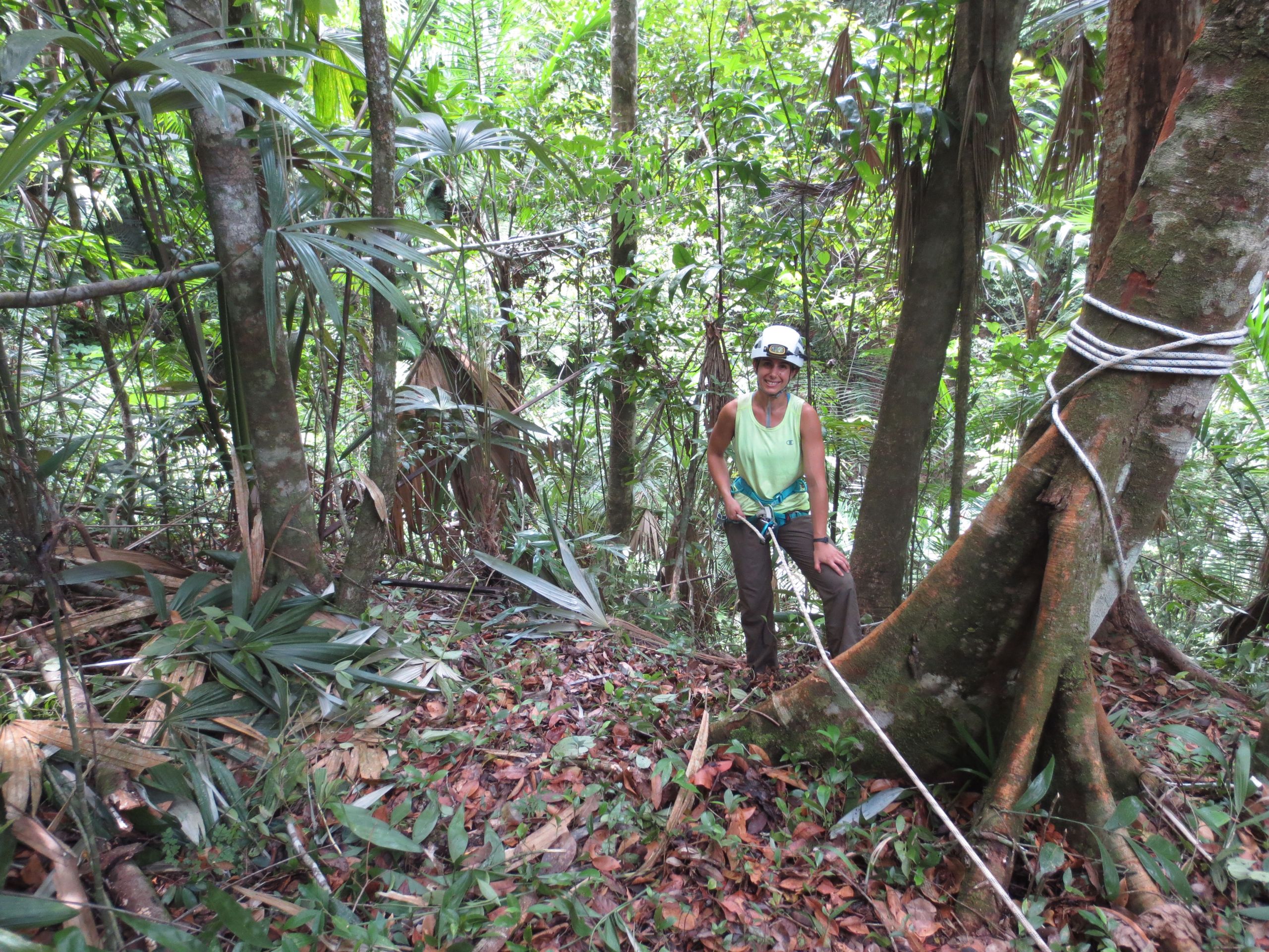

In 2018, Leila Character (previously Donn), C’08, was finishing up her master’s work in geoarchaeology with field work in Guatemala, looking for caves that might contain material of interest to archaeologists, when a camera crew from National Geographic showed up at the research site. The crew was working on a documentary about advances in remote imaging that help archaeologists find structures hidden by jungle vegetation, and Character and her research partners had just found a promising site in a cave the day before. The research team had spent the season looking for caves, and as a smaller woman, Character was always first in. “It could be terrifying,” she says. “At one point I was convinced I heard a large cat, like a jaguar, purring. I screamed. It is the most scared I have been in my life, but it turned out to be bats’ wings fluttering.”
For the cave filmed by National Geographic, she squeezed through an 18-inch opening for 50 feet before the passage opened up into a room that had been formed by a collapsed floor. “In that exposed layer, we saw charcoal [potential evidence of human activity] and sherds,” Character says.
The next day, with the National Geographic team in tow, the researchers reenacted the discovery, with the videographer following Character into the cave, pushing the camera ahead of him, while belly-crawling across the rocks. The footage was good enough that Character and her team were featured in the first 15 minutes of the documentary, “Hidden Treasures of the Maya.”
Fast forward a year, and Character appeared in another video, this time only about a minute long and in Belize rather than Guatemala. She is looking thoughtfully at a GPS device in front of a bluff surrounded by tropical forest and a cave entrance, when the videographer, Mike Mallner, a caving friend from Tennessee, asks a question:
“How are you feeling right now?”
“Pretty happy.”
“And why is that?”
“Because this computer program I made to tell us where a cave is … is telling us where a cave is.”
In fact, not only did Character’s computer program predict that cave location, within a few weeks the efficacy of the program was proven over and over. “The model predicted 100 locations,” says Character. “We set out to ground-truth 25 sites, and 24 were caves, rock shelters, or chul’tuns [Mayan manmade caves used for storage and burial].” Before the work that summer, few such sites had been found in Belize. “The most exciting find was a 200-foot-deep sinkhole,” she says. “Nothing like this had ever been documented.”
“When I came home, I started thinking about using machine learning to discover caves in a tropical forest. No one had ever done that, and I think my advisor might have thought I was crazy.”
The idea for the overachieving computer program came out of the work in Guatemala. “Finding caves is really hard work,” Character says. “In fact, at one point the National Geographic director told the camera man, ‘Zoom in on Leila’s face. She’s really hot and sweaty.’ We only found that cave after nine hours of off-trail hiking, with biting insects and heat and just a lot of effort.” The team found the cave just before they would need to turn back before evening came. In other videos, the group discusses monkeys that throw sticks at the traveling researchers as they make their way across the landscape. They are ragtag adventurers battling considerable challenges.

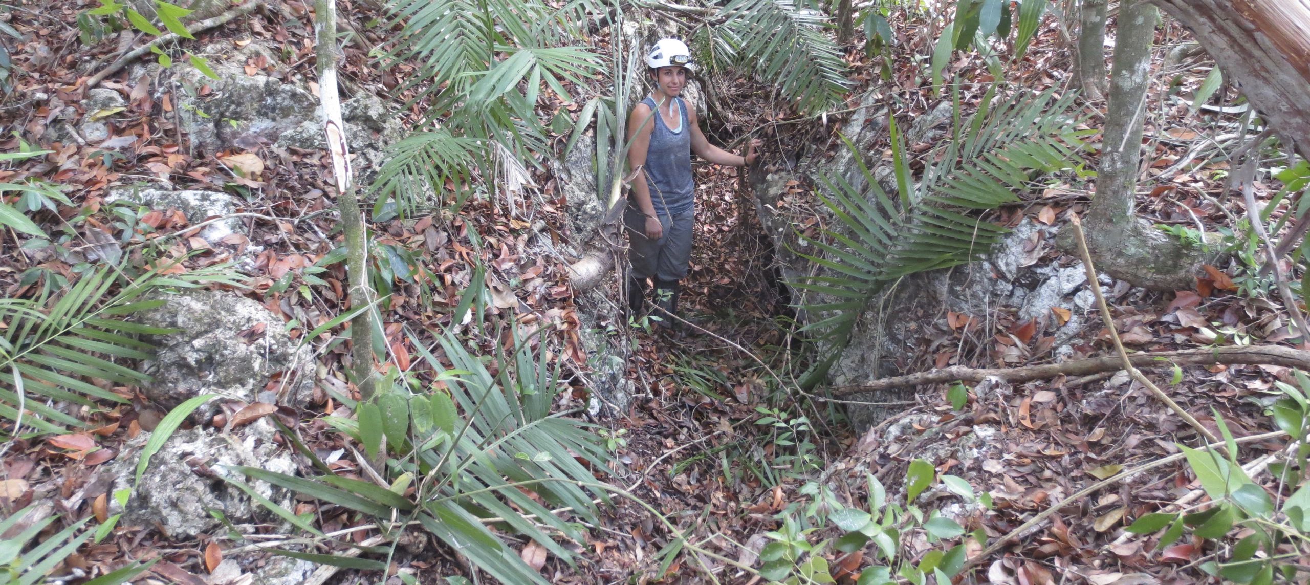
Right where she thought it would be: Leila Character discovers a small cave entrance at a location in Belize indicated by her software.
Right where she thought it would be: Leila Character discovers a small cave entrance at a location in Belize indicated by her software.
The difficulty of discovery, even aided by contemporary remote sensing, has a significant negative impact on researchers. Too often, a journey to a potential site yields nothing, and precious time during the field season is given over to a fruitless search. That difficulty inspired a new project for Character as she entered a Ph.D. program in Geography and the Environment at the University of Texas. “When I came home, I started thinking about using machine learning to discover caves in a tropical forest. No one had ever done that, and I think my advisor might have thought I was crazy,” says Character. But she set out to do the project anyway.
What she had in mind was a model that employed machine learning, which involved training a program to consider many mathematical variables associated with a landscape. “Shallow learning has been around a long time,” she explains. “It’s what Amazon does when it suggests things for you to buy or when Netflix makes viewing recommendations.” Shallow learning applies fairly simple rules to data to come up with an answer that can be remarkably accurate. (Yes, you will purchase those granola bars.) Deep learning, on the other hand, breaks up the picture into thousands of patterns. “Deep learning is powerful for perceptual tasks but requires a lot of data,” explains Character, “thousands or millions of images, and it is computationally intensive.” It also enables a hands-off approach by the researcher so that less bias is introduced.
“Machine learning is becoming more used in archaeology because of deep learning,” says Character. “Deep learning is particularly suited to applying to archaeological features because it can identify different size and shaped iterations of the same thing. Sometimes it can even identify features that aren’t visible or perceptible to a human.”
Once Character had developed the basic structure for her computer program, she faced another challenge—training the model what a cave would look like. To do that, she turned to her alma mater and her former professors and their colleagues at Sewanee. Geology Professor Steve Shaver asked Chris Van de Ven at Sewanee’s Landscape Analysis Laboratory to share geographic data with Character. Van de Ven sent data of the Domain gathered using remote-sensing LiDAR as well as a GPS file with known cave locations. The training work was grueling. Character assigned every pixel an array of values for slope, elevation, curvature, and other factors. “It’s really hard to find a cave using imagery,” she explains. “Not every cave looks the same, but with machine learning that task becomes doable.”
“Deep learning is particularly suited to applying to archaeological features because it can identify different size and shaped iterations of the same thing. Sometimes it can even identify features that aren’t visible or perceptible to a human.”
The GPS file from Sewanee had caves represented by GPS points that had no diameter to them. Before she could run the model, she needed to draw circles around the GPS points to better represent the actual portion of the topographic surface that contains the cave entrance. Based on her knowledge of cave entrances on the Domain, she settled on 10-meter circles. ”I was particularly excited to get to work with LiDAR and cave data from Sewanee just because I love Sewanee and was excited to get to do a project that involved them.”
In the same way the Domain trained the program, Character credits Sewanee with instilling a particular kind of curiosity in her. “Every one of my projects include field work,” she explains. “Like many Sewanee students, I came out interested in field science, and I was also inspired to always be looking to develop hard skills. About the time I graduated, machine learning was beginning to blow up. I wanted to learn to code to control ArcGIS [a well-known program for managing geographic data]. Then I moved to more general Python coding.”
Character is an adventurer, happiest hiking or climbing or caving while also relishing the adventure of coding—seeing the connections between machine learning and the field. In fact, she has employed the same general methodology and concepts from the “computer program to find caves” to several other cases. “The model is replicable and transferable,” she says. She has worked with the U.S. Navy to find shipwrecks, with a group of researchers from Austin on a project to locate pine trees at the Air Force Academy that are infected with pine bark beetles, and with archaeologists in Romania trying to discover the location of tumuli (ancient burial mounds). For each application, the training of the model is different, but the basic methodology is the same, down to the testing of the model in the field. “Modeling and field work—it’s all complementary.”
With only her dissertation to complete before earning the PhD, Character is also working for a startup in the artificial intelligence field, Third Insight, where she is head of research and strategy. “We are interested in combining perception with contextual understanding to enable human-like problem-solving in real time,” she says. While the archaeology that provided a genesis for her work tracks persistent features on the landscape, her real goal is to track the way landscape changes. And while her technological chops are emergent in her work, it’s the caving, the hiking, the climbing, and the squeezing into impossibly small passages—the landscape itself—that animate her.
